
I’m writing this from Sant Antoni de Portmany, Ibiza, but this time instead of a coffee in hand it is a G&T, Spindrift is finally resting quietly at the dock. This post is for my friends who like passage planning. This crossing really starts a few days earlier, back in Garrucha, reading books, talking to locals, staring at weather models and trying not to outsmart myself. And as you would expect this passage, like all passages, should start with the synoptic view of this area…..and in this case the Tramontana is in the room and you must pay attention.
I have surmised that in these parts from reading Cornell that there’s a certain optimism that can come with casting off from Garrucha (or areas in the vicinity) bow pointed east toward the Balearics. The charts look simple enough. Open water, a clean line to Ibiza. About 195 nautical miles, a day and change if the wind cooperates.
In the western Mediterranean however, the wind between the mainland and the islands has a name: the Tramontana. If the Levante (see previous post) is the gatekeeper of the Strait of Gibraltar, the Tramontana is the bouncer of the Balearic Sea. Cold, dry, and in no mood to let you through. It funnels down off the continent through the gaps in the Pyrenees and accelerates across the open water like it has somewhere important to be. Which it does. Directly into your face.
It can turn a straightforward crossing into a steep, confused slog in a matter of hours. So planning this passage isn’t really about distance. It’s about timing. And humility. Mostly humility.
The Trap
Here’s the thing I have learned about the Tramontana that gets people; it starts with beautiful weather. A front passes, pressure rises, the sky goes blue and crisp and inviting. What a perfect day to go sailing, you think, already untying the dock lines in your head.
Don’t. At least not until you’ve looked more.
That clearing sky can be the beginning of the blow, not the end of it. The high-pressure system building over Europe is about to shove cold continental air south through the Pyrenees like toothpaste through a tube. Give it a day. Let the pressure gradients relax. Let the sea state settle. The best window is after the Tramontana has thrown its tantrum and gone home.
Coming from the U.S. East Coast, I’m still focused on and fascinated by these recurring wind patterns in the Med. Back home, weather systems set in and stay. It feels to me that the cycles here are shorter and more severe. A front moves through at home and you’ve got days before things shift again. Here, a blow might last two days and die overnight. The seas are steep and confused because the fetch is short and the wind changes its mind before the waves get organized. Miss your window by half a day and you’re sitting in port for another three.
Siblings: The Tramontana and the Mistral
The Tramontana doesn’t work alone. It has a bigger, meaner sibling: the Mistral.
They’re born from the same weather pattern. High pressure building over western or central Europe, low pressure over the Mediterranean, and the pressure gradient between them driving cold continental air south. The difference is which mountain gap the air gets squeezed through.
The Tramontana takes the western corridor, accelerating between the Pyrenees and the Massif Central before launching across the Balearic Sea. The Mistral takes the eastern corridor, funneling down the Rhône Valley between the Massif Central and the Alps, and blasting out into the Gulf of Lion and beyond. Same cold, dry, northerly air, different exit ramps off the continent.
They often fire at the same time. Which they were doing on the 12th.
This matters for route planning because the Tramontana can die down in your crossing window while the Mistral is still howling to the northeast. That’s exactly what happened during our passage. The Tramontana spent itself by the 14th, but the Mistral kept blowing east of the Balearics and might keep blowing until the 17th. If we’d been heading to Corsica or Sardinia instead of Ibiza, different story entirely.
Reading the Models
This is where PredictWind earns its keep. For departure planning, we can compare up to four forecast models side by side and look for agreement. PredictWind offers seven to choose from: PWG, PWE, ECMWF, GFS, AIFS, UKMO, and ICON. Picking the right four matters. You want accuracy, but you also want independence. If your four models all share the same underlying data, they’ll agree with each other even when they’re wrong. False confidence is worse than no confidence.
Here’s what we picked for this crossing, and why:
ECMWF, the European Centre for Medium-Range Weather Forecasts model. The most accurate global model in the world and our anchor of the four. Nothing beats it for reading pressure gradients, frontal timing, and the large scale patterns that drive winds like the Tramontana.
PWE, PredictWind’s proprietary high-resolution model. It runs ECMWF data through a downscaling engine at 1km resolution, which is where you start seeing what global models miss: thermal effects along the coast, wind acceleration through mountain gaps, the way land masses bend the flow. For a passage shaped by air being squeezed through the Pyrenees, that resolution matters.
UKMO, the UK Met Office’s Unified Model, which ranks second globally behind ECMWF. The key here is independence. ECMWF and PWE share the same DNA, so if ECMWF has a blind spot, PWE inherits it. UKMO is built on completely different data assimilation and physics. When ECMWF and UKMO agree, you can trust the forecast. When they don’t, you know the uncertainty is real.
ICON, Germany’s global model from the DWD. Different grid, different physics, and particularly strong in European waters. For a Med crossing driven by pressure patterns over France and Iberia, it adds real diversity as a fourth pick.
We left GFS out (the weakest of the seven for European waters) and AIFS (ECMWF’s own AI model, which shares too much DNA with ECMWF to add real independence).
When all four tell the same story, you go. When they disagree, you wait. It’s that simple. And they said “go” on April 14th.
So Were We Walking Into Our Own Trap?
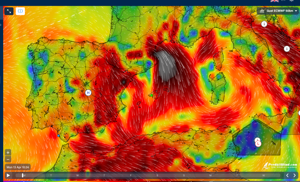
This was the question we were asking ourselves on April 13th, sitting in Garrucha with everything stowed and ready to go, trying to figure out if we were about to be the idiots in our own blog post. The Balearics were in full Tramontana mode. Gale-force winds, ferry cancellations, flights delayed out of Palma, waves up to three meters. Meanwhile, the Mistral was hammering the waters east of the islands. The kind of day that makes you glad to be in port with a bottle of wine and a book.
Here’s what the wind looked like on April 13th, when the Tramontana and its sister were throwing a temper tantrum. And in fact you can see a full on Poniente in the Strait of Gibraltar. A full on temper tantrum!
By the 14th, the wind was still blowing from the north-northwest but dying. We had a high-pressure system developing over Garrucha and the Balearics, and the temptation to leave was strong. Blue sky, flat water in the harbor. Classic trap conditions.
But here’s what we were seeing on the models: by the morning of the 14th, our planned departure, the wind was forecast to clock around. Mid-passage, overnight, the models showed it shifting to the southwest, behind us or dying. By the afternoon of the 15th, it would die to almost nothing. Wave heights across the entire crossing window? Under one meter.
That was the tell. If the Tramontana were still active, or rebuilding, we’d have been looking at two to three meter seas and a stubborn northerly refusing to let go. Instead, the wind was clocking through 180 degrees, the seas were flattening, and the pressure gradients were going slack. This wasn’t the trap. This was the window, the one the rest of this blog post tells you to wait for.
All four models agreed. ECMWF, PWE, UKMO, and ICON were telling the same story: settled conditions, light to moderate winds from the southwest on the passage, dying light by arrival. When the models agree, you go.
The Route and Arrival
From Garrucha, you’re committed to open water quickly, with limited bailout options once you’re offshore. There are some. But there’s no convenient chain of harbors to duck into if things go sideways mid-way. This is not a coastline that believes in safety nets.
Looking at Navily we had two basic plays. We could step the passage east along the coast toward Cartagena or Cabo de Palos first, then make the jump to the islands. This gives us options. If the Tramontana shows up early, you can tuck in behind the cape and pretend you meant to stop there all along. Or we could go direct when a solid window appears, cutting straight across open water. Bolder, faster, and slightly more committed.
The deciding factor was what the wind was doing once we were off of Cabo de Palos. Any hint of north in the forecast, and the coastal approach starts looking a lot smarter. The Tramontana has a way of making bold decisions feel stupid in hindsight. For this crossing we had concurrence. The wind was going to fill in from the south or drop out altogether. So we went for it. This was confirmed while we were south of Cabo de Palos.
Arrival planning matters just as much as departure, because the islands have very different personalities depending on the wind. A northerly means exposed anchorages, uncomfortable harbors, and the occasional lee shore surprise. Show up on the wrong side of an island after an overnight passage, tired, and you’ll find yourself fighting the coast instead of celebrating your arrival. This is the nautical equivalent of driving across town to a restaurant that turns out to be closed. For us on this crossing we expected a southerly or no wind at all and we got it.
We aimed for Sant Antoni de Portmany on Ibiza’s west coast, sheltered from any residual northerly, with the island blocking whatever the Tramontana had left in the tank. It’s a small adjustment on the chart that makes a big difference at the end of a long crossing. This paid off.
The Models Delivered
I’ll save the full story of the crossing for the weekly post, where I’ll go into detail about the passage itself, the night watches, and what it’s like out there between the mainland and the islands.
But the short version: we cast off from Garrucha at 0602 UTC, 0802 local on April 14th, and tied up in Sant Antoni de Portmany roughly 31 hours later. 195 nautical miles. Two thirds under sail, maybe about a third under power, all of it on schedule. The models proved right. The Tramontana had thrown its tantrum and gone home, exactly when they said it would. And its evil sister the Mistral is still throwing a tantrum as I sit here with my G&T. We waited well, and the waiting paid off.
A crossing like this doesn’t happen on instinct. It happens on information, software, reference books[^1][^2][^3], local knowledge, and a healthy respect for what you don’t know. I’ll do a separate post on the full toolbox we use for passage planning.
Not Stress, Engagement
People often ask if passage planning is stressful. I’ve heard it enough times that it’s worth addressing. The short answer is: not the way you think.
It’s not stress. It’s intensity. It’s attention. Ocean sailing demands focus, self reliance, and a commitment to what is happening right now and what might happen next. I find myself constantly asking questions. Am I fully aware of my surroundings? Have I properly read the conditions and the signs? Is the boat ready? Are Sarah and I in the right mindset? Am I taking an unnecessary risk, or simply making a sound decision? That process is engaging rather than overwhelming. It feels active and deliberate. It switches on every sense I have. Isn’t that how life should be lived?
I’ve spent time in very different environments, maybe too much time, like luxury resorts where everything is taken care of. Meals appear, logistics disappear, and there’s very little that requires ongoing decision-making or attention. There’s real value in switching off completely. But for me, it can also dull the senses. The constant awareness that I value fades into the background.
Ocean sailing gives you both. When you finally arrive at the dock or the mooring, tied up, engine off, lines secured, that’s when the ease comes. You’ve earned it. The relief and the stillness are sweeter because of what came before. This is exactly the feeling Sarah and I had today when we med moored in Sant Antoni de Portmany….and had a great dinner on the harbor.
That’s what this is to me. Not stress. Complete engagement with the moment. Feeling switched on.
From Garrucha to Ibiza, success isn’t measured in miles made good. It’s measured in patience, and knowing when the patience is over.
Fair winds from S/V Spindrift
[^1]: Jimmy Cornell, World Cruising Routes, 7th edition, updated 2015.
[^2]: Islas Baleares, edited by David and Susie Baggaley, Imray, 12th edition, 2023.
[^3]: Mediterranean Spain: Costas del Sol and Blanca, edited by Steve Pickard, Imray, 2nd edition, 2021.

Leave a reply to Anthony Mercurio Cancel reply